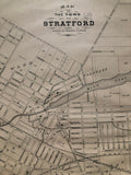
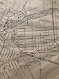
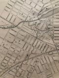
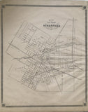
Map of the Town of Stratford [Perth County, Southwestern Ontario]
Scale 15 chains - 1 Inch
21 x 17 3/4 inches (53.2 x 45.2 cm)
antique map (upper left corner chipped, few short tears and staining to margins, ‘Town’ has been crossed out in pencil and ‘city’ written in pencil)
from The New Topographical Atlas of The Province of Ontario. Toronto: Miles & Co., 1879.
Map features Avon Ward, Falstaff Ward, Romeo Ward, Shakespeare Ward and Hamlet Ward.
Landmarks include: The B. & L.H. Branch G.T.R.Y. (Buffalo and Lake Huron Railroad on the Grand Truck Railway), Albion Hotel, Knox Church, St. Andrews Church, a brewery, Avon River, a market, a Mill Pond, Thompson & Williams, a Courthouse, a Cemetery, registry offices, Mansion Hotel, Roman Catholic Church, other churches, schools and streets.
CLICK TO VIEW OUR OTHER STRATFORD MAP
Go back in time and trace the history of the Ontario & it's ancestors and maybe even your own!
own a piece of Ontario Local History & Genealogy
~If you're looking for a particular town, city, township or county please contact us and we will let you know what we have.
*Map will be mailed flat and not in a tube. Please contact us if you would prefer to have it rolled
**Custom Framing available! Please contact us for details.

![1879 Antique Map of the Town of Stratford [Perth County, Southwestern Ontario]](http://delakeltd.com/cdn/shop/products/IMG-4673_1_{width}x.jpg?v=1607987362)


![1879 Antique Map of the Town of Stratford [Perth County, Southwestern Ontario]](http://delakeltd.com/cdn/shop/products/IMG-4673_1_compact.jpg?v=1607987362)


