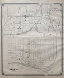
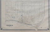
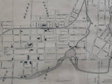
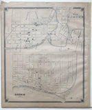
Antique Map of Sarnia and Map of Simcoe [ Norfolk County & Lambton County, Southwestern Ontario]
19 x 16 inches (48.3 x 40.8 cm)
sheet measures: 21" x 18"
Original antique map (light staining and to margins, tear to upper left corner, couple 2 short tears to lower margin).
from The New Topographical Atlas of The Province of Ontario. Toronto: Miles & Co., 1879.
Sarnia landmarks include: street names, St. Clair River, St. George cemetery, Methodist cemetery, high school, tannery, water works, fair grounds, churches, jail, court house, registry office, Indian Reserve, town hall, Sarnia Brewery, Customs Wharf House, Bank of Montreal, Bank of Commerce, Market square. skating rink, Meritt Oil Refinery and Railway.
Simcoe landmarks include: Lynn River, Gore of Woodhouse, County of Norfolk Agricultural Society Grounds, Steam Cooperag Work, Dr. Duncomber, Post office, Empire block, churches, post office, Distillery and mill, Wilsons Block, Battersby, Court House, Registry office, Union School, Port Dover & Lake Huron railroad and depot, Dean's Hotel, Oak Lodge, Kents Brewery, Fire Engine Station, Windham Mills,Wilsons Mill Pond, Great Western Railway and station
Go back in time and trace the history of the Ontario & it's ancestors and maybe even your own!
own a piece of Ontario Local History & Genealogy
~If you're looking for a particular town, city, township or county please contact us and we will let you know what we have.
*Map will be mailed flat and not in a tube. Please contact us if you would prefer to have it rolled
**Custom Framing available! Please contact us for details.


