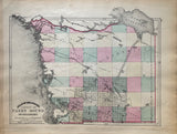
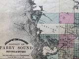
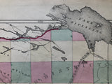
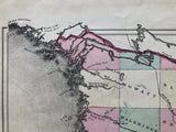
George N. Tackabury's Antique Map of The District of Parry Sound [Central Ontario]
Scale Six Miles to an Inch.
11 1/2" x 15" (29.5 x 38 cm)
sheet measures: 13 1/2" x 17 1/2"
original antique map, original hand-coloured lithograph (some browning to edges, two stains to upper margin.
from TACKABURY'S Atlas Of the Dominion of Canada, Montreal: 1875.
Townships include: Mowat, Blair, Walbridge, Brown, Wilson, McKenzie, Ferrie, Lount, Hagerman, Croft, Chapman, Carling, Ferguson, McKeller, Spence, Ryerson, McDougall, Cowper, Foley, Cristie, Monteith, McMurrich and Perry.
Landmarks & Towns include: Lake Nipissing, Namanitigong River, Nipissing Road, French River, Georgian Bay, Bustard Island, the Indian Islands, The Limestone Islands, Perry Island, Perry Sound, Old Trading Post, Small Lake, The Key, Henvey Inlet, Byng Inlet Post Office, Still River, Rapid River, Magnetawan River, Great North Road, Naiscoutang River, Shawanaga River, Trading Post, Franklin Inlet, McKeller Post Office, Ahmic Lake, Lake Cecebe, Doe Lake, Waubamik Post Office, Trout Lake, Mill Lake, Seguin River, Turtle Lake Post Office.
Go back in time and trace the history of the Ontario & it's ancestors and maybe even your own!
own a piece of Ontario Local History & Genealogy
~If you're looking for a particular town, city, township or county please contact us and we will let you know what we have.
*Map will be mailed flat and not in a tube. Please contact us if you would prefer to have it rolled
**Custom Framing available! Please contact us for details.


