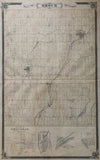
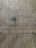
1877 Antique Map of Brock Township [Ontario County / Durham Region, Southern Ontario]
25 1/4 x 15 1/2 inches (63.9 x 39 cm)
sheet measures: 27 1/4" x 17 1/2"
original antique map (some staining and soiling, couple short tears to margins, lower left corner chipped).
from the Illustrated Historical Atlas of the County of Ontario, Toronto: J.H. Beers, 1877.
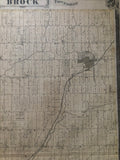
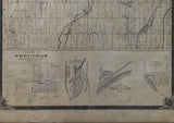
Towns & Villages marked: Layton, Wick, Pinedale, Sunderland, Valentye, Vroomanton, Wilfred, Derryville, Cannington with insets along of the bottom of the map of the Village of Brougham (Pickering), Washago, Village of Port Union & Village of Fairport (Pickering).
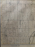
Landmarks include: churches, schools, post offices, mills, railroad lines, Nonquon River, and landowners.
Some landowners include: R. Doble, John Phair, Robert Mooney, James Bagshaw, George Bagshaw, L. Bagshaw, W. Bagshaw, M. Bagshaw, W. Bagshaw Jr., John St. John, George Hadden, L. McPhail, N. McNeil estate, A. McMillian, D. McMilian, William Rundle, William Innis, T. Rundle, E. Rundle, William Baird, R. Baird, William Carmichael, N. McPhaden, Alex McPhaden, John Thompson, George Thompson, James Waddle, M. Gillespie, E. Acton, James Ruddy, William Doble, Jno. Acton, Jas. Acton, James Doble, C. St. John, Robert Doble, G. St. John, Julius St. John, George Hodgson, Daniel Ross, William McCaskill, D. Brown, C. Gibbs, R.L. Shier, Sam Shier, L. Wilson, John Glendinning, J. Oke, James Glendinning, H. Glendinning, W. Valentine, T. Valentine, James Purvis, R.H. Shier, A. Shier, Robert Shier, John Johnson, John Edwards, William Francis, James Vrooman, S. Vrooman, H. Brethour, J. Umphrey, John Boyle, Julius W. Shier, J. Sharp, J. McMaster, R. Sproul, J. Sproul, A. Currie,
Go back in time and trace the history of the Ontario & it's ancestors and maybe even your own!
own a piece of Ontario Local History & Genealogy
Brock Township was first surveyed in 1817 and named after Major General Sir Isaac Brock (1769-1812) whose estate received free land for his service in the War of 1812. William Bagshaw was Brock's first Post Master and Justice of the Peace in 1819. Many members of the Bagshaw family are shown on this map.
Vroomanton was named after its founder Colonel James Vrooman, who was granted land in 1820 for his participation in the war of 1812. J. Vrooman and S. Vrooman both appear on this map. S. is most likely his brother Solomon who also fought in the War of 1812.
Other early settler families of Brock township include: Acton, Charters, Dusto, Purvis, Rundle, Bagshaw, Doble, Phair, St. John, Umphrey, Brethour, Doyle, Fallowdown, Ruddy and Vrooman, Wilson, Glendenning, Oke, Shier, Keenan and Speiran.
~If you're looking for a particular town, city, township or county please contact us and we will let you know what we have.
*Map will be mailed flat and not in a tube. Please contact us if you would prefer to have it rolled
**Custom Framing available! Please contact us for details.

![1877 Antique Map of Brock Township 1877 [Ontario County / Durham Region, Southern Ontario]](http://delakeltd.com/cdn/shop/products/IMG-1326_{width}x.jpg?v=1645632302)


![1877 Antique Map of Brock Township 1877 [Ontario County / Durham Region, Southern Ontario]](http://delakeltd.com/cdn/shop/products/IMG-1326_compact.jpg?v=1645632302)
