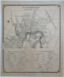
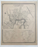
Antique Map of City of St. Catherines 1879 [Lincoln County / Niagara Region, Southeastern Ontario]
19 x 16 inches (53.4 x 44.3 cm)
sheet measures: 21" x 17"
Original antique map (couple creases along left portion, short tears & chips to margins, small stain to top margin).
from The New Topographical Atlas of The Province of Ontario. Toronto: Miles & Co., 1879.
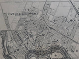
includes St Patrick's Ward, St. James Ward, St. Paul's Ward, St. Thomas' Ward
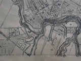
Landmarks include: Welland Canal, Dick's Creek, Welland Railway, Great Western Railway, railway stations & buildings, Canal lock house, hospital, churches, schools, post office, town hall, registry office, St. George's English Church, drill shed and street names.
includes statistics for two adjacent counties - Wentworth and Brant are feature in the lower portion of the map.
Go back in time and trace the history of the Ontario & it's ancestors and maybe even your own!
own a piece of Ontario Local History & Genealogy
St. Catherines is named after Catherine Hamilton, the wife of Robert Hamilton, an successful merchant of Queenston and a landowner with mills on Twelve Mile Creek. The growing community, originally known as The Twelve or Shipman's Corners, was renamed St. Catherines in her honour after her death in 1796.


