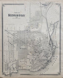
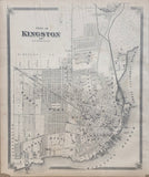
19 1/2 x 15 3/4 inches (49.4 x 40 cm)
sheet measures: 21" x 17 1/2"
Original antique map (some spotting & soiling, lower corners chipped, tear to upper margin).
from The New Topographical Atlas of The Province of Ontario. Toronto: Miles & Co., 1879.
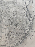
includes: Rideau Ward, Victoria Ward, Sydenham Ward, Ontario Ward, St. Lawrence Ward, Cataraqui Ward, Frontenac Ward.
Landmarks include: street names, Kingston Harbour, Great Cataraqui River, boat yard, Water works, City Brewer, foundry, ship yard, Spice mills, Locomotive works, Wharf & Customs house, St. Lawrence Lake Ontario Wharf, Martello Tower, Battery, Wolfe Island Wharf, Tete du Pont Barracks, Frontenac Smelting Works, Grand Trunk Railroad and Station, Place d'Arms, Gas works, City Hotel, Albion Hotel, Market Place, City Hall, Anglo American Hotel, British American Hotel, Merchant's Bank of Canada, Montreal bank, St. Paul's Church, College of Regiopolis, Royal Artillery Park, hospital, R.C. Bishop Palace, Grammer School, Jail, Court House, Cricket Grounds, Queen's College, Drill Shed, Frontenac Brewery, Bellevue Terrace, Loyola College, public park, orphanage, Cemeteries, churches, Tannery.
Property owners include: J. Gale, J. Gibson, C. Kappe, Thomas Kalbarn, Jno. Bryant, Henry Sands, William H. Reid, R. Bryant, David Trotter, Edward Bryant, Jas. Robbs, Jno. Bryant, A. Wilder and others.
Go back in time and trace the history of the Ontario & it's ancestors and maybe even your own!
own a piece of Ontario Local History & Genealogy
~If you're looking for a particular town, city, township or county please contact us and we will let you know what we have.
*Map will be mailed flat and not in a tube. Please contact us if you would prefer to have it rolled
**Custom Framing available! Please contact us for details.


