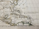
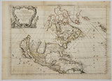
17th Century Antique Map of North America
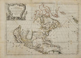
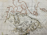
SANSON, Nicolas [1600-1667] / ROSSI, Giacomo de [Publisher Active 1650-1690]. L’America Settentrionale Nuouamente corretta, et accresciula secondo le relationi… da Guglielmo Sansone… E data in luce da Giacomo De Rossi in Roma… 1677… Giorgio Widman Sculp.
16” x 22” (40.7 x 55.8 cm). original outline colour. horizontal & vertical folds, (light foxing, two small rust stains, paper weak in two areas, few tears to folds & upper margins repaired).
_______________________________________________________________________________________________
Rossi 1677 edition of Sanson’s 1669 Amerique Septentrionale. Sanson’s map provided an early accurate rendering of the Eastern Great Lakes, but, Lake Superior and Michigan were depicted as open-ended. The map shows the Atlantic coast as far south as Panama and the northwest coast as far west as ‘Agubela de Cato’. California is shown as an island.
Tooley, The Mapping of America, p. 122 No. 42.


![SANSON, Nicolas [1600-1667] / ROSSI, Giacomo de [Publisher Active 1650-1690]. L’America Settentrionale Nuouamente corretta, et accresciula secondo le relationi… da Guglielmo Sansone… E data in luce da Giacomo De Rossi in Roma… 1677](http://delakeltd.com/cdn/shop/products/20220927_161337_2_{width}x.jpg?v=1664474763)

![SANSON, Nicolas [1600-1667] / ROSSI, Giacomo de [Publisher Active 1650-1690]. L’America Settentrionale Nuouamente corretta, et accresciula secondo le relationi… da Guglielmo Sansone… E data in luce da Giacomo De Rossi in Roma… 1677](http://delakeltd.com/cdn/shop/products/20220927_161426_{width}x.jpg?v=1664474763)


![SANSON, Nicolas [1600-1667] / ROSSI, Giacomo de [Publisher Active 1650-1690]. L’America Settentrionale Nuouamente corretta, et accresciula secondo le relationi… da Guglielmo Sansone… E data in luce da Giacomo De Rossi in Roma… 1677](http://delakeltd.com/cdn/shop/products/20220927_161337_2_compact.jpg?v=1664474763)
![SANSON, Nicolas [1600-1667] / ROSSI, Giacomo de [Publisher Active 1650-1690]. L’America Settentrionale Nuouamente corretta, et accresciula secondo le relationi… da Guglielmo Sansone… E data in luce da Giacomo De Rossi in Roma… 1677](http://delakeltd.com/cdn/shop/products/20220927_161426_compact.jpg?v=1664474763)
