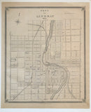
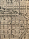
Map of the Town of Lindsay 1879 [Victoria County, Kawartha Lakes, Southeastern Ontario]
Scale 10 cm to 1 in
20 7/8 x 17 3/8 inches (53.2 x 44.2 cm)
antique map (soil stain to right corner of margin)
from The New Topographical Atlas of The Province of Ontario. Toronto: Miles & Co., 1879.
Landmarks include: the Scucog River, Whitby Port Perry and Lindsay Railway, Victoria Railway, Midland Railway, lock up, town hall, Factories, drill shed, south Victoria Agricultural society’s show grounds, registry office, flour mill, wharf, brewery, railway lumberyard, saw mills, railway stations, cemeteries, churches, schools, a hotel, streets & the estates of George Kempt & John Knowlson.
George Kempt emigrated from Scotland with his family in 1831 and became a Canadian businessman and politician, representing Victoria South as a liberal in the 1st Canadian Parliament. He also served in the local Lindsay council and as sheriff for Victoria County.
Go back in time and trace the history of the Ontario & it's ancestors and maybe even your own!
own a piece of Ontario Local History & Genealogy
~If you're looking for a particular town, city, township or county please contact us and we will let you know what we have.
*Map will be mailed flat and not in a tube. Please contact us if you would prefer to have it rolled
**Custom Framing available! Please contact us for details.


