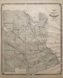
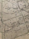
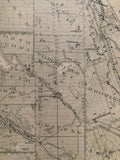
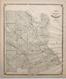
Map of the County of Renfrew [Eastern Ontario]
Scale 2 1/2 miles to 1 Inch.
20 3/4 x 17 6/8 inches (52.6 x 45.1 cm)
antique map (minor soiling to margins)
from The New Topographical Atlas of The Province of Ontario, Toronto: Miles & Co., 1879.
Includes: Fraser Township, Alice Township, Stafford Township, Westmeath Township, North Algona Township, South Algona Township, Wilberforce Township, Bromley Township, Ross Township, Sebastopol Township, Grattan Township, Admaston Township, Horton Township, Griffith Township, Broughham Township, Bagot Township, McNab Township and Blythfield township.
Lakes & Bodies of water include: Bonnechere River, Golden Lake, Silver Lake, Beaver Lake, Clear Lake, Philips Lake, Highland Creek, Highland Lake, Trout Lake, Bass Lake, otter Lake, Mountain Lake, Mud Lake, Muskrat Lake, Round Lake, Kelly Lake, Strain Lake, Indian River, Hates Creek, Green Lake, Lake Dore, Mink Lake, Hurds Creek, [Perrault Lake], Constant Creek & Constant Lake, Condon Lake, White Fish Lake [Centennial Lake], Black Donald Creek, Ottawa River, Cranberry Lake, Coulonge Lake, Snake River, Rocher Fendu Lake, Lac du Chat, Shaw Lake, Colton Lake, [Samally Lake], Miller Lake, Norway Lake, Calabogie Lake, Stones Lake, Hurds Lake, Madawaska River, Olsmstead Lake, Catherine Lake, Coldingham Lake, & White Lake
*Hawley’s Island and Allumette Island, Quebec are featured in the upper right corner of the map.
Towns: Vanbrugh, Clontarf, Griffith, Matawatchan, Locksley, Rankin, Eganville, Dacre, Mount St. Patrick, Pembroke, Stafford, Mickburg, Osceola, Douglas, Northcote, Admaston, Shamrock, Calabogie, High Falls, Bagot, Perretton, Westmeath, Gower Point, Beachburgh, Foresters Falls, Haley Station, Ross, Harcourt, Renfrew, Castleford, Lochwinnoch, Carswell, Sand Point, Burnstown, Stewartville, Braeside, Mansfield Village, and Arnprior.
Go back in time and trace the history and growth of Ontario!
own a piece of Ontario Local History
~If you're looking for a particular town, city, township or county please contact us and we will let you know what we have.
*Map will be mailed flat and not in a tube. Please contact us if you would prefer to have it rolled
**Custom Framing available! Please contact us for details.


