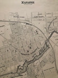
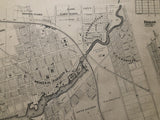
Map of Napanee [Lennox and Addington County, Eastern Ontario]
Scale 8 chains to an Inch
17 6/8 x 20 6/8 inches (45 x 52.6 cm)
antique map (offsetting to right portion of map)
from The New Topographical Atlas of The Province of Ontario. Toronto: Miles & Co., 1879.
Map features Original Napanee, Upper Napanee, South Napanee, Cartrightville [Cartwrightville], Clarkville, Briggs (sub. Division).
Landmarks include: Napanee River, Rathburn Reserve, agricultural grounds and Crystal Palace, Town Hall & Market square, Campbell House, Mill reserve, dam, Napanee Falls, flour mills, tanneries, Schools, cemeteries, churches, a wharf, Grand Trunk Railway & railway buildings, and streets
Property owners identified on this map include: Luke Carscallen, J. Lucas, J.S. & J.R. Cartwright, William Miller, Mrs. Andrews, [Archibald McNeil], Mrs. Stevenson, Thos. Briggs and others.
Go back in time and trace the history of the Ontario & it's ancestors and maybe even your own!
own a piece of Ontario Local History & Genealogy
~If you're looking for a particular town, city, township or county please contact us and we will let you know what we have.
*Map will be mailed flat and not in a tube. Please contact us if you would prefer to have it rolled
**Custom Framing available! Please contact us for details.

![1879 Antique Map of Napanee [Lennox and Addington County, Eastern Ontario]](http://delakeltd.com/cdn/shop/products/IMG-4696_{width}x.jpg?v=1607988452)


![1879 Antique Map of Napanee [Lennox and Addington County, Eastern Ontario]](http://delakeltd.com/cdn/shop/products/IMG-4696_compact.jpg?v=1607988452)

