


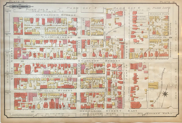

GOAD, Charles E. Plate 16 from the Atlas of the City of Toronto
17 x 26 inches (43.3 x 66.3 cm)
antique coloured map, a couple paste-over revisions as issued(minor browning, couple tears with no loss, longest approx. 2")
Published Toronto: 1890. This map is from the second major edition of Goad’s Atlas of the City of Toronto.
a fascinating look into the history of Toronto’s ever changing face
This map covers Yonge St. to Homewood Ave & Allan Horticultural Gardens and Alexander Street to Gerrard St. E. and features parts of the Toronto's downtown Garden District & the Church & Wellesley Neighbourhood
Landmarks include Allan Horticultural Gardens, Young Men's Association, Gooderham Hall, St. James Presbyterian Church, Ontario College of Pharmacy, St. Andrews Church & Sunday School, Toronto Collegiate Institute, and others.
Estates of Judge Boyd, Mrs. Edward C. Rutherford, Dr. W.T. Aikins, Walter S. Lee and others.
Charles E. Goad (1848-1910) was a noted cartographer and civil engineer. He was born in Camberwell, England, and emigrated to Canada in 1869. Goad is most well known for his fire insurance and special survey plans of cities in Canada, Great Britain, and elsewhere. Fire insurance companies needed to know in detail the nature and size of buildings, width of streets, construction, building materials and the proximity of fire services and water supplies in order to estimate appropriate premiums. Goad established a company (the Charles E. Goad Company) in 1875 in Montreal, Canada to produce maps. These and like maps are now referred to as Goad maps. At the time of his death in 1910, Goad had produced plans for approximately 1,300 communities in Canada and overseas.
Fire insurance plans were produced primarily at a uniform scale of fifty feet to one inch (scale), which Goad maintained, would permit both clarity and economy. At this scale, multiple sheets often were needed to document a community, in which case a smaller scale key or index plan was created to provide quick reference. It should be noted that in cases where individual sheets are missing from a set of plans, it is often because certain page numbers were intentionally omitted in order to reserve space to document future urban expansion. The availability of plans was advertised through circular letters prepared by Goad.
Plans were revised on a limited but regular basis through a system of "correction slips" or " updating stickers ", Markers, or "blue slips" were placed on the top right-hand corner of plans to indicate the date on which the correction slips were applied. When insurance companies requested revisions, re-surveying occurred. Sheets of individual corrections were first prepared, corrections were cut out, update stickers prepared and placed in envelopes according to the correction sheet reference. Plans were returned by subscribers to the Goad office for corrections to be pasted on the plans upon which they were sent back to the subscriber. New editions of plans were produced only after the correction slips and updating stickers began to interfere with the legibility of the plan. A new procedure for revisions was introduced in 1950 by the Underwriters' Survey Bureau Limited. The introduction of smaller sheets (13" x 13") and improved printing techniques meant that new sheets could be printed when revisions were required. These sheets can be identified by the use of the notation "Partially Revised".
Plans are typically colour-coded to denote building construction materials: pink indicates brick, blue indicates stone, and yellow was used to illustrate frame construction. A standard key of signs was established and often appears on the plans to assist in decoding the information. The layout of the plans remained quite uniform over the years, with the first page providing the title, dates and imprint. The second page typically includes the “Key plan”, with the exception of larger plans, where the “Key plan” appears on the first sheet.
~If you are looking for a particular intersection or street please contact us and we will let you know if we have a neighbourhood you're looking for~
*Map will be mailed flat and not in a tube. Please contact us if you would prefer to have it rolled
**Custom Framing available! Please contact us for details.