Original c1772 Antique Map of North America
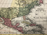
DELISLE, Guillaume[1967-1726] / LOTTER, Tobias Conrad [1717-1777]. America Septentrionalis Concinnata juxta Observationes... Per G. de L'Isle Geographum... apud Tobiam Conr. Lotter... [Augsburg: c1772].
18 3/4" x 22 3/4" (47.6 x 57.6 cm)
original colour (few tears to margins - one with old repair affecting one cm of upper border, some creasing & spotting to margins).
________________________________________________________________________________________________
Lotter edition of Delisle's L'Amerique Septentionale. This state has a different decorative cartouche with Neptune (on the right) and two men on the left holding an oar and pouring water. This map shows North America as far west a California, but, with area north of 'C. Mendocin' is left blank. There are tracks of several Pacific exploration routes including Drake, and Mendana.
Wagner 630. Tooley, The Mapping of America, p. 19, No. 34.

![DELISLE, Guillaume [1967-1726] / LOTTER, Tobias Conrad [1717-1777]. America Septentrionalis Concinnata juxta Observationes... Per G. de L'Isle Geographum... apud Tobiam Conr. Lotter... [Augsburg: c1772].](http://delakeltd.com/cdn/shop/products/IMG-4265_bda9fcde-d1e4-4f97-ae45-730eab104459_{width}x.jpg?v=1664211484)
![America Septentrionalis Concinnata juxta Observationes... Per G. de L'Isle Geographum... apud Tobiam Conr. Lotter... [Augsburg: c1772].](http://delakeltd.com/cdn/shop/products/IMG-4267_{width}x.jpg?v=1664211484)
![Guillaume Delisle [1967-1726] / LOTTER, Tobias Conrad [1717-1777]. America Septentrionalis Concinnata juxta Observationes... Per G. de L'Isle Geographum... apud Tobiam Conr. Lotter... [Augsburg: c1772].](http://delakeltd.com/cdn/shop/products/IMG-4269_{width}x.jpg?v=1664211484)


![DELISLE, Guillaume [1967-1726] / LOTTER, Tobias Conrad [1717-1777]. America Septentrionalis Concinnata juxta Observationes... Per G. de L'Isle Geographum... apud Tobiam Conr. Lotter... [Augsburg: c1772].](http://delakeltd.com/cdn/shop/products/IMG-4265_bda9fcde-d1e4-4f97-ae45-730eab104459_compact.jpg?v=1664211484)
![America Septentrionalis Concinnata juxta Observationes... Per G. de L'Isle Geographum... apud Tobiam Conr. Lotter... [Augsburg: c1772].](http://delakeltd.com/cdn/shop/products/IMG-4267_compact.jpg?v=1664211484)
![Guillaume Delisle [1967-1726] / LOTTER, Tobias Conrad [1717-1777]. America Septentrionalis Concinnata juxta Observationes... Per G. de L'Isle Geographum... apud Tobiam Conr. Lotter... [Augsburg: c1772].](http://delakeltd.com/cdn/shop/products/IMG-4269_compact.jpg?v=1664211484)

