


![Jacques Nicolas Bellin [1703-1772]. Partie Orientale De La Nouvelle France Ou Du Canada Par Mr. Bellin Ingenieur du Roy et de la Marine [Paris]: 1755.](http://delakeltd.com/cdn/shop/products/20220927_160924_{width}x.jpg?v=1664473218)


![Jacques Nicolas Bellin [1703-1772]. Partie Orientale De La Nouvelle France Ou Du Canada Par Mr. Bellin Ingenieur du Roy et de la Marine [Paris]: 1755.](http://delakeltd.com/cdn/shop/products/20220927_160937_2_{width}x.jpg?v=1664473218)
![Jacques Nicolas Bellin [1703-1772]. Partie Orientale De La Nouvelle France Ou Du Canada Par Mr. Bellin Ingenieur du Roy et de la Marine [Paris]: 1755.](http://delakeltd.com/cdn/shop/products/20220927_160924_grande.jpg?v=1664473218)


![Jacques Nicolas Bellin [1703-1772]. Partie Orientale De La Nouvelle France Ou Du Canada Par Mr. Bellin Ingenieur du Roy et de la Marine [Paris]: 1755.](http://delakeltd.com/cdn/shop/products/20220927_160937_2_grande.jpg?v=1664473218)
Jacques Nicolas Bellin Antique Map of Eastern Canada (Quebec & Atlantic Canada)
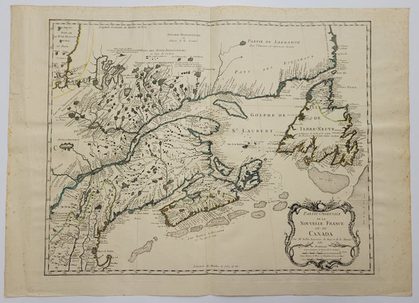
Jacques Nicolas Bellin [1703-1772]. Partie Orientale De La Nouvelle France Ou Du Canada Par Mr. Bellin Ingenieur du Roy et de la Marine [Paris]: 1755.
19 1/2” x 24 1/2” (plate mark measurements; 49.7 x 62.3 cm). engraving on watermarked paper. original outline colour (small pinhole, crease to left margin & light foxing to margins & verso).
_______________________________________________________________________________________________
First issued in 1745, the 1755 edition of the Partie Orientale was extensively revised. “Numerous changes have been made to the plate…with changes to the Saint Lawrence River, Lake Ontario, Cape Cod, and with the addition of “Nouvelle York”…”. (Kershaw p. 5) Bellin included the recently established town of Halifax, Acadia. There are many Newfoundland coastal place-names, including ‘La Pointe Riche”.
Kershaw, Early Printed Maps Of Canada, 689 & Plate 494. Heindenreich & Dahl, The French Mapping of North America 1600-176o, pp. 15.16.