


![BLAEU, Joan [1596-1673]. Regiones Sub Polo Arctico Auctore Guilielmo Bleau. [Amsterdam: c1648-1662].](http://delakeltd.com/cdn/shop/products/IMG-4261_{width}x.jpg?v=1664212506)


![BLAEU, Joan [1596-1673]. Regiones Sub Polo Arctico Auctore Guilielmo Bleau. [Amsterdam: c1648-1662].](http://delakeltd.com/cdn/shop/products/IMG-4261_grande.jpg?v=1664212506)


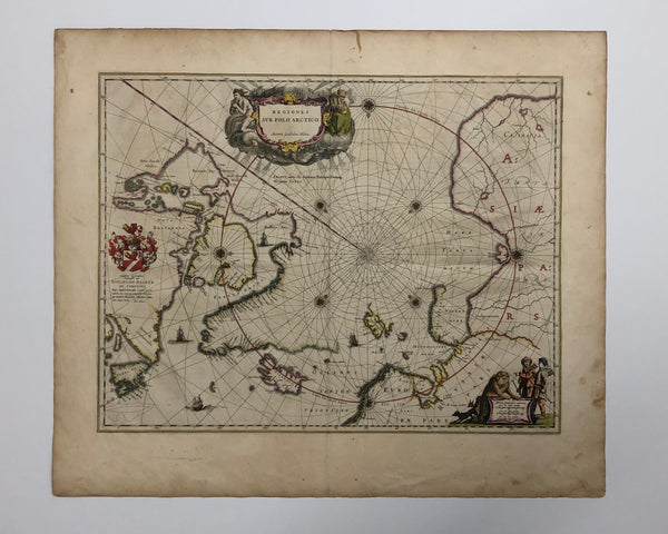
17th Century Antique Map of the Arctic
BLAEU, Joan [1596-1673]. Regiones Sub Polo Arctico Auctore Guilielmo Bleau. [Amsterdam: c1648-1662]. Latin text on verso, Map 4 & Signature C.
16" x 20 1/2" (40.6 x 52.1 cm).
Original colour (short tear to lower margin and some soiling & staining to margins).
________________________________________________________________________________________________
Second State - Searching For the Northwest and Northeast Passage
With crest and dedication to G. Backer de Corneliis. Blaeu's map of the Arctic was published shortly after Jansson's, almost identical, Nova Et Accurata Poli Arctici.
Blaeu's map of the Arctic provides an important summation of the state of geographical knowledge in respect to the polar regions. Utilizing information gained from the explorations of James, Hudson, Baffin, Frobisher and Davis, the map shows Spitzbergen, Nova Zembla, Russia, Greenland, Iceland and Asia. The Regiones Sub Polo Arctico is very attractively decorated with an interesting cartouche depicting, presumably, two inhabitants of the region, although one is naked and the other, bundled up with a coat and hat. The cartouche is surrounded by allegorical figures blowing cold air. At the lower right, there are illustrations of two hunters, a bear and foxes.
Koeman I Bl 23B. Glenbow Museum, The Canadian West Discovered, p. 23, Map 7. Kershaw 127. Burden 252.